
Resource
Georgia Redistricting and Congressional Districts
Here’s how Georgia’s demographics have changed since the last time maps were drawn — and what those changes mean for this decade’s redistricting cycle.


Part of

The Georgia legislature is expected to pass new state legislative and congressional district maps in a special session starting November 3. The purpose of this process is to account for population changes that have occurred over the past decade as measured by recently released 2020 Census data. In Georgia, these changes have been significant, with the state’s population growing by 10.5 percent, from 9,687,653 to 10,711,908 people, between 2010 and 2020.
As in 2011, when districts were last drawn, Republican lawmakers in Georgia have complete control over the process. But the legal landscape has shifted for the worse since then. Because of a 2013 Supreme Court ruling striking down a key provision of the Voting Rights Act, Georgia will no longer have to submit its maps to the U.S. Department of Justice or a federal court in Washington, DC, to ensure they do not discriminate by race. It will be the first time in six decades that the state did not need preapproval before implementing its maps. And in a 2019 ruling, the Supreme Court also foreclosed the possibility that federal courts could serve as a backstop to partisan gerrymandering, no matter how brazen or extreme.
Thus, Georgia’s 180 state house, 56 state senate, and 14 congressional districts are being drawn under single-party control without critical safeguards against racial discrimination or partisan abuses. This analysis summarizes Georgia’s major population trends of the last decade, both statewide and in metro Atlanta, and examines their redistricting implications.
Highlights:
- Black, Latino, Asian, and multiracial Georgians collectively account for all of Georgia’s population growth between 2010 and 2020. The white population shrank both proportionally and in absolute terms over the course of the decade.
- Fifty-one percent of Georgia’s population gains are concentrated in five metro Atlanta counties — Gwinnett, Fulton, Cobb, Forsyth, and DeKalb. These counties outpaced all others in terms of growth, and they now have numbers to support increased representation, including three additional state house districts.
- In recent years, the rapid growth of communities of color has reshaped the politics of the Atlanta suburbs as multiracial coalitions press for and have been increasingly successful in winning political power. With the Atlanta suburbs likely to be one of Georgia’s key redistricting battlegrounds this decade, a central issue to watch will be whether lawmakers attempt to undermine these gains — and whether they refuse to create new electoral opportunities.
Statewide Analysis
Georgia gained over 1 million new residents from 2010 to 2020. Though a number of counties across Georgia’s Black Belt and in other rural communities saw their total numbers decrease slightly over the last decade, the rest of the state’s population grew rapidly, ranking fourth among all states in total population growth.1 According to estimates from 2019, about half of this change is attributable to natural increase2 and half due to international immigration and domestic in-migration.3
This substantial population growth was not distributed equally across the state or across racial groups. In fact, Georgia’s white population shrank over the last decade, both in absolute and relative terms. As of 2020, there are 51,764 fewer white Georgians than there were in 2010. This decrease in white population makes the growth in Black, Latino, Asian, and multiracial populations even more notable — they account for 100 percent of the population growth. In absolute terms, Georgia’s Black and Latino populations grew the most, adding 367,319 and 269,768 additional people respectively. The Asian population added 163,988 people, growing by 53 percent since 2010, which is the highest for a single racial group.4 These demographic trends hold when Georgia’s citizen voting age population, which is often used in redistricting as a stand-in for those eligible to vote, is considered.5
Because Georgia’s population growth is concentrated in geographic pockets, largely in urban and suburban areas, the number of districts in these areas should increase. Indeed, over the course of the last decade, many rural counties saw their population numbers decrease or hold steady. Meanwhile, areas around greater Augusta and Savannah saw healthy increases, and the population of metro Atlanta boomed.
Collectively, Fulton, Gwinnett, Cobb, Forsyth, and Dekalb Counties — all rapidly diversifying communities covering Atlanta and some of its suburbs — added 524,202 people, or just over half of Georgia’s total population growth from 2010 to 2020. By the numbers, these fast-growing metro Atlanta counties should pull three state house districts and about two-thirds of a congressional district from regions of the state that have shrunk or stagnated.6 The question will be whether the legislature actually increases the representation of Atlanta and its suburbs or uses populations in other parts of the state to minimize their political influence.
Regional Analysis
Homing in on the metro Atlanta counties puts a finer point on the statewide trends. Unsurprisingly, Black, Latino, and Asian communities represent the lion’s share of population growth in the burgeoning region, home to nearly 4 in 10 Georgians. The following map, which shows change in the nonwhite share of the population by census tract from 2010 to 2020, reveals how this growth has transformed some of Atlanta’s suburbs from predominantly white into multiracial communities.
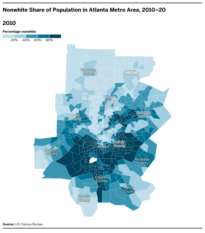
Many of these areas were once known for their status as “white flight” destinations in the latter part of the 20th century. Now, many have racial and ethnic pluralities.7 In large part, this is thanks to significant in-migration from other U.S. cities, such as New York, Miami, and Chicago.8 Many of those coming to metro Atlanta are younger Black professionals, part of the reverse Great Migration as Black Americans move back to the South a century after millions of their ancestors began fleeing Jim Crow segregation in pursuit of opportunities in other parts of the country.9
Immigration has also been a significant driver of the Atlanta region’s growth since 2010. Cobb, DeKalb, Forsyth, Fulton, and Gwinnett Counties are home to flourishing immigrant communities. In Gwinnett County, for example, a quarter of residents were born in another country — nearly 20 percent of whom immigrated to the U.S. in the last decade.10 Clarkston, a town in DeKalb County, has even been called the Ellis Island of the South and “one of the most successful resettlement communities in the world.”11 These migration patterns have contributed to the growth of Black, Latino, Asian, and multiracial populations in metro Atlanta.
These demographic shifts have had real political consequences. Democrats Joe Biden, Raphael Warnock, and Jon Ossoff won close statewide races in the 2020 election cycle, largely because of their strong performances among increasingly diverse suburban Atlanta voters.12 Sometimes overlooked, however, are the changes that have occurred at the state and local levels. Since 2018, three suburban counties elected their first Black sheriffs, and Gwinnett County voters elected Georgia’s first female Asian state senator as well as 20 Black women to state, county, and municipal offices.13 Put simply, voters of color and emerging multiracial coalitions are becoming an increasingly effective political force.
At the same time, this growing political power could meet with backlash. Redistricting plans that fail to create additional electoral opportunities for voters of color, or even dismantle districts where voters of color have enjoyed success, would almost certainly be challenged under the Voting Rights Act. But it is uncertain whether such challenges would succeed, given the Supreme Court’s increasingly restrictive interpretations of voting rights laws and its greenlighting of partisan gerrymandering.
Conclusion
Georgia’s population has undergone a profound evolution over the course of the last decade. Whether redistricting will account for the rapid population growth and diversification, particularly in the metro Atlanta suburbs, will be key to understanding the electoral landscape in Georgia.
Endnotes
-
1
2020 U.S. Census PL 94–171 redistricting data summary files and 2010 U.S. Census data show that Georgia added the fourth most people of all states between 2010 and 2020, trailing only Texas, Florida, and California. Georgia ranks 13th in relative population growth. U.S. Census Bureau 2020 Census PL 94–171 Redistricting Summary File, https://www.census.gov/programs-surveys/decennial-census/about/rdo/summary-files/2020.html, and 2010 Census Summary File 1 Data, https://www.census.gov/data/datasets/2010/dec/summary-file-1.html. -
2
Natural increase is estimated to be responsible for 483,669 of the 928,964 people added to Georgia’s population between 2010 and 2019 — 52 percent of the state’s growth. U.S. Census Bureau, “Table 4. Cumulative Estimates of Resident Population Change of the United States, Regions, State, and Puerto Rico” and “Region and State Rankings: April 1, 2010 to July 1, 2019,” December 2019, available at https://www.census.gov/data/tables/time-series/demo/popest/2010s-state-total.html. -
3
The net migration of an estimated 441,756 people to Georgia from 2010 to 2019 is responsible for 48 percent of its growth during that time period. Of those in-migrants, 188,808 (43 percent) came from outside the United States and 252,948 (57 percent) from other parts of the country. U.S. Census Bureau, “Table 4. Cumulative Estimates of Resident Population Change of the United States, Regions, State, and Puerto Rico” and “Region and State Rankings: April 1, 2010 to July 1, 2019,” December 2019, available at https://www.census.gov/data/tables/time-series/demo/popest/2010s-state-total.html. In 2019, California, Florida, Texas, South Carolina, North Carolina, and Tennessee were the top senders of population to Georgia. U.S. Census Bureau, “Table 1. State-to-State Migration Flows: 2019,” from the 2019 American Community Survey 1-Year Estimates, https://www.census.gov/data/tables/time-series/demo/geographic-mobility/state-to-state-migration.html. -
4
Because the Census Bureau categorized write-in responses to the race and ethnicity questions differently in 2020 than in 2010, the number of people reported in the 2020 data as identifying with multiple racial groups is expected to be higher. In other words, part of this increase likely reflects actual growth, but part of it can be attributed to methodological changes. Hansi Lo Wang, “What the New Census Data Can — and Can’t — Tell Us About People Living in the U.S.,” NPR, August 12, 2021, https://www.npr.org/2021/08/12/1010222899/2020-census-race-ethnicity-data-categories-hispanic; and Rachel Marks and Merarys Rios-Vargas, “Improvements to the 2020 Census Race and Hispanic Origin Question Designs, Data Processing, and Coding Procedures,” U.S. Census Bureau, August 3, 2021, https://www.census.gov/newsroom/blogs/random-samplings/2021/08/improvements-to-2020-census-race-hispanic-origin-question-designs.html. -
5
Detailed comparisons of citizen voting age population changes over the past decade are omitted here due to a lack of equivalent data sources, as work on the special tabulations of the voting-eligible population for 2020 has been suspended indefinitely. U.S. Census Bureau, “Post-2020 Census CVAP Special Tabulation,” October 30, 2020, https://www.census.gov/programs-surveys/decennial-census/about/voting-rights/cvap/Post-2020-CVAP.html. However, comparisons of the American Community Survey 5-Year Estimates for 2010 and 2019 demonstrate that the total population trends detailed in this piece have been steadily emerging among the citizen voting age population over the past decade. -
6
Ideal district population sizes are calculated by dividing the total population of Georgia (9,687,658 in 2010 and 10,711,908 in 2020) by the number of Georgia districts in the relevant category (56 for state senate, 180 for state house, and 14 for Congress). The ideal size for a state house district was 53,820 in 2010 and 59,511 in 2020; for a state senate district,172,994 in 2010 and 191,284 in 2020; and for a congressional district, 691,975 in 2010 and 765,136 in 2020. Fulton County, for example, would have been entitled to 17.1 state house districts in 2010 and has enough people for 17.9 state house districts in 2020, meaning the number of districts it could support increased by 0.8 over the past decade due to population growth. Combined figures for the top five growth counties in the metro Atlanta region were calculated by adding these county representational differences together. -
7
In 2010, 51 percent of Atlanta metro area residents lived in a census tract where white people made up less than half of the population. By 2020, 64 percent of Atlanta residents — over 3 million people — lived in a census tract where nonwhite people made up the majority. U.S. Census Bureau 2020 PL 94–171 Redistricting Data Summary File, accessed via Social Explorer. -
8
U.S. Census Bureau, “Metro Area-to-Metro Area Migration Flows,” from the 2018 American Community Survey 5-Year Estimates, https://www.census.gov/data/tables/2018/demo/geographic-mobility/metro-to-metro-migration.html. -
9
Khushbu Shah, “Black ‘Reverse Migration’ Driving Atlanta and Georgia Towards Democrats,” Guardian, October 22, 2018, https://www.theguardian.com/cities/2018/oct/22/black-reverse-migration-atlanta-brian-kemp-stacey-abrams-governor-midterms-voter-suppression; “Why Some Black Millennials Are Moving South,” WBUR, August 8, 2017, https://www.wbur.org/hereandnow/2017/08/08/black-millennials-moving-south; and Meg Cunningham, “In Atlanta, Reverse Migration Is Beginning to Skew Suburbs Blue,” ABC News, November 20, 2019, https://abcnews.go.com/Politics/atlanta-reverse-migration-beginning-skew-suburbs-blue/story?id=67106895. -
10
U.S. Census Bureau, 2015–2019 American Community Survey 5-Year Estimates, https://www.census.gov/data/developers/data-sets/acs-5year.html. -
11
Patrik Jonsson, “Ellis Island of the South,” Christian Science Monitor, January 17, 2016, https://www.csmonitor.com/USA/Society/2016/0117/Ellis-Island-of-the-South. -
12
Mireya Villarreal, “Biden Becomes the First Democrat to Win Georgia Since 1992, CBS News Projects,” CBS News, November 13, 2020, https://www.cbsnews.com/news/joe-biden-georgia-first-democrat-win-since-1992-cbs-news-projects/; and Nate Cohn, Matthew Conlen, and Charlie Smart, “Detailed Turnout Data Shows How Georgia Turned Blue,” New York Times, November 17, 2020, https://www.nytimes.com/interactive/2020/11/17/upshot/georgia-precinct-shift-suburbs.html -
13
“Gwinnett, Cobb, Henry Counties Elect First Black Sheriffs in History,” WSB-TV Atlanta, November 5, 2020, https://www.wsbtv.com/news/politics/gwinnett-cobb-henry-counties-elect-first-black-sheriffs-history/VOQCE7GQPFFU3FONDQEP6H46OA/; Curt Yeomans, “As Back-to-Back Blue Waves Hit Gwinnett County, It Has Been Black Women Leading the Shift,” Gwinnett Daily Post, February 28, 2021, https://www.gwinnettdailypost.com/local/as-back-to-back-blue-waves-hit-gwinnett-county-it-has-been-black-women-leading/article_bed4a416–6343–11eb-90ee-bfaf4e145ace.html; and Maya T. Prabhu, “Two Georgia Senators Tell Story of Changing Gwinnett County,” Atlanta Journal-Constitution, March 24, 2021, https://www.ajc.com/politics/two-georgia-senators-tell-story-of-changing-gwinnett-county/3MNISECPS5FCNHE76UZ5HL73AA/.
More from the Redistricting and Changing Demographics in Key States series
-
North Carolina Redistricting and Congressional Districts
Here’s how North Carolina’s demographics have changed since the last time maps were drawn — and what those changes mean for this decade’s redistricting cycle. -
Texas Redistricting and Congressional Districts
Here’s how Texas’s demographics have changed since the last time maps were drawn — and what those changes mean for this decade’s redistricting cycle. -
Florida Redistricting and Congressional Districts
Here’s how Florida’s demographics have changed since the last time maps were drawn — and what those changes mean for this decade’s redistricting cycle.


Stay up to date