Every ten years, states redraw the boundaries of their congressional and state legislative districts after the census. Who does the line drawing varies state by state.
The way districts are drawn can have a big impact on both voters and politicians. It can influence who wins elections, how political power is distributed, which communities are represented, and what laws are passed. This creates a powerful incentive to manipulate district lines for political gain. And over the last two decades, these manipulations have grown increasingly common and sophisticated.
However, recent years have seen a significant growth in efforts to protect the redistricting process from abuse. While the vast majority of states continue to let their legislatures draw districts, there is a growing movement toward alternative approaches to mapdrawing. Citizen-driven ballot initiatives let to the passage of redistricting reforms in Arizona in 2000 and in California in 2008 and 2010. Since then, voters in Colorado, Michigan, Missouri, New York, Ohio, and Utah have also adopted changes to improve the redistricting process.
With another round of redistricting in 2021, many state legislatures are currently considering redistricting reforms. Visit our Redistricting Reform Tracker for information on redistricting bills currently pending before legislatures.
The following maps show who is currently responsible for redistricting in the United States
State Legislature
State legislatures currently are responsible for drawing congressional districts in 31 states and state legislative districts in 30.
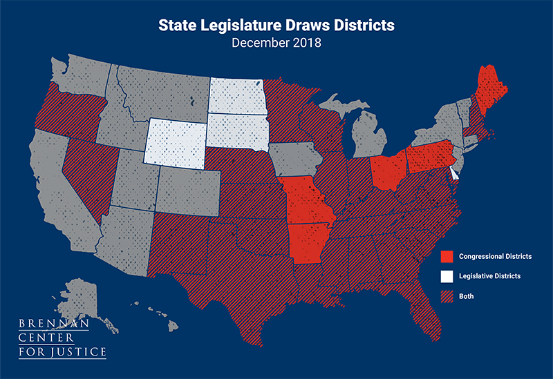
In most states, the legislature passes redistricting plans as regular legislation. Plans often must be approved with a majority vote in each chamber and are subject to veto by the governor, but a few states exclude the governor from the process. State legislative plans in Florida, Maryland, and Mississippi are not subject to gubernatorial veto. In North Carolina, neither congressional nor state legislative plans are subject to gubernatorial veto.
Advisory Commission
Four states use an advisory commission to draw congressional plans, and six states have an advisory commission to draw state legislative districts.
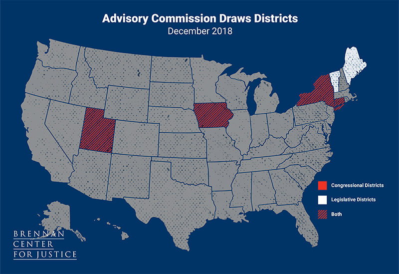
Advisory commissions, which may consist of legislators or non-legislators or a mix, recommend redistricting plans to the legislature. The advisory commission draws the maps, then the legislature has the final say in approving them, usually by an up or down vote. Connecticut and Maine require a plan to be passed with a 2/3 majority of the legislatures, and in Connecticut, the plan is not subject to gubernatorial veto.
Independent Commission
Four states use an independent commission for both congressional and state legislative districts.
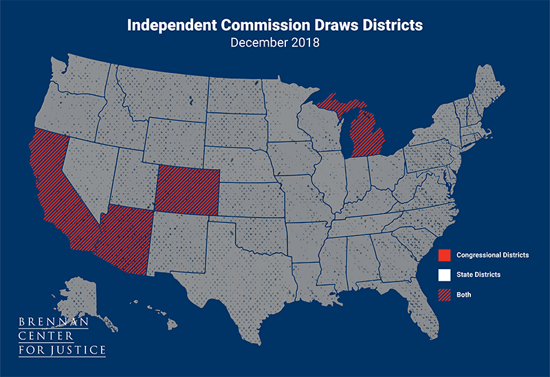
Independent commissions are made up of members who are neither public officials nor current lawmakers and are selected with the help of a screening process that is conducted by an independent entity. Commissioners are responsible for drawing and approving the final maps.
Political Appointee Commission
Four states use a political appointee commission for congressional plans, and nine states use this type of commission for state legislative plans.
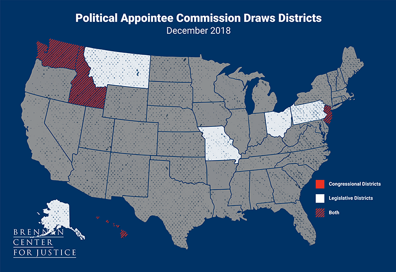
Political appointee commissions are composed of individuals who are directly appointed by elected officials, party leadership, or political party committees. In some states, the membership of a political appointee commission is evenly divided between parties, while others allow members of one party to hold more seats on the commission than the other. Ohio uses a hybrid between a political appointee commission and a politician commission to draw its state legislative districts.
Politician Commission
One state, Arkansas, uses a politician commission for state legislative districts.
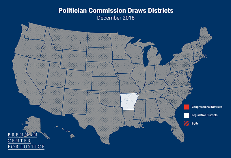
Politician commissions are comprised entirely of incumbent lawmakers or other elected officials, usually appointed by the legislative or party leadership, the governor, or chief justice of the state supreme court.
Backup Commission
Three states use a backup commission for congressional plans and five for state legislative plans.
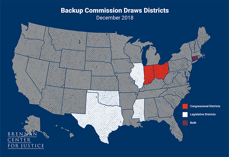
Backup commissions are called on to draw maps when the legislature is deadlocked or when the governor vetoes the proposal. Ohio’s backup commission draws the congressional map if the legislature fails to pass a plan with bipartisan support.
Single District States
Seven states currently have only one congressional district.
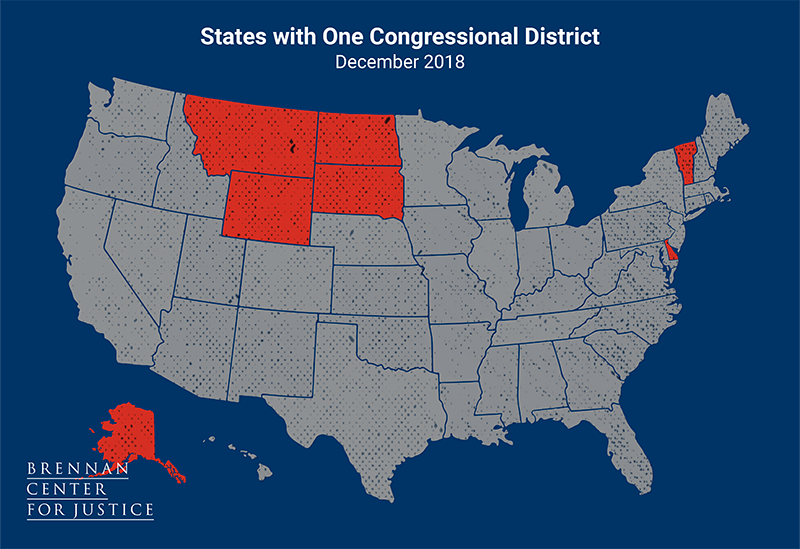
Following the 2020 Census, however, Montana may gain one congressional seat. In that case, the state’s political appointee commission will draw both congressional and state legislative lines in 2021. Rhode Island may lose one of their two seats, becoming a single district state.